Sunday, February 3, 2013
Containers and Container Art
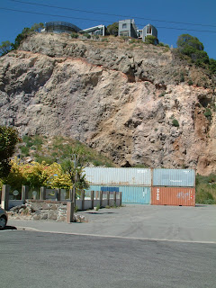
Containers full of ballast are used to protect people, property and roadways from falling rocks destabilised by the earthquake and subsequent thousands of aftershocks.
In the spirit of rebuilding a stronger and more earthquake-resistant Christchurch, many containers have become advertising hoardings and canvasses for art.
Above the road to the West of Sumner. The many properties which are behind this long line of containers which included a Church, Croquet Club,Armed Forces Club and numerous houses have been "Red-Zoned" because of the unstable nature of Richmond Hill cliffs.
This shows the West (Seaside) End of Richmond Hill Cliffs. The Marine Club to the left foreground is red-zoned as are the once expensive homes on the cliff-top. The containers are there to prevent falling rocks rolling onto the roadway which is bang in the centre of Sumner's shopping area.
Peacock's Gallop
The following 5 photos show an area known as "Peacocks Gallop" West/Sea facing cliffs overlooking a picnic area (now an ex-picnic area) and the coast road from Sumner to ChCh. In the second photo you can see how much has fallen away and what is left of the properties on top. I still find it unbelievable that planning consent is apparently so easy to get in an earthquake zone (and I remember saying it repeatedly to Carole on our first trip in 2010)
Redcliffe (Coast road North of Sumner)
The final picture is taken from the beach at Peacock's Gallop looking North towards Redcliffe. Though slightly overexposed, framed by Shag Rock (now Shagged Rock) in the right foreground, the massive rockfall at Redcliffe can be seen in the distance. Redcliffe School sits at the foot of this cliff and is now cordoned-off and no longer in use. Many properties on this cliff are red-zoned.
Subscribe to:
Comments (Atom)


